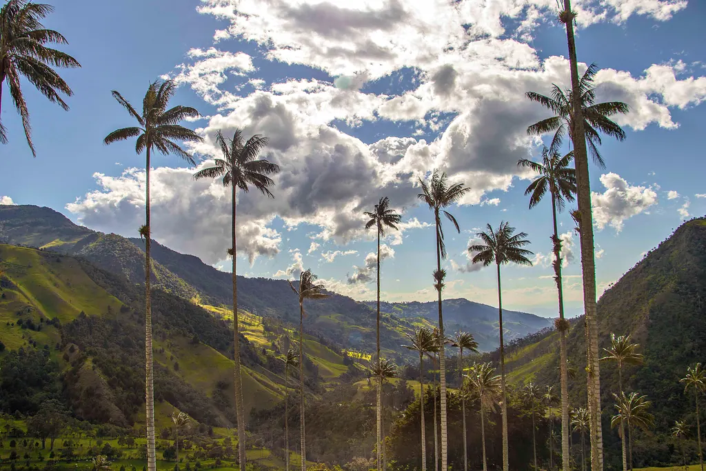
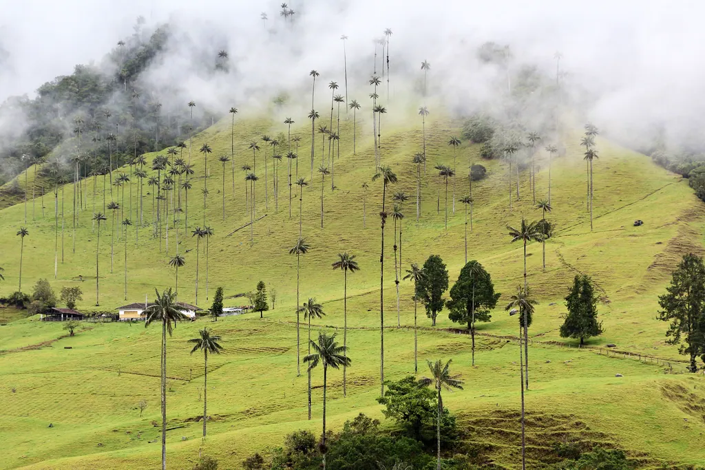
The first thing that surprises most visitors is the height of the palms. In the Cocora Valley, above the small town of Salento, wax palms rise out of steep green pastures like a forest drawn by a child who ran out of paper: thin gray trunks shooting up toward the clouds, with a small crown of leaves at the very top. The second surprise is the coffee. You can drink it on the bush, in a sense, at a farm a few minutes from where it was grown, picked and dried.
This is Colombia's Coffee Region, the Eje Cafetero, a green, mountainous corner of the Andes west of Bogotá. It is slower and cooler than Cartagena and less visited than Medellín, and for many travelers it becomes the part of Colombia they talk about afterward. Here is what makes it special, how to plan a few days there and what to keep in mind about safety.
Where Is the Coffee Region?
The Coffee Region sits on the slopes of the Central and Western ranges of the Andes, roughly between Medellín and Cali. It is usually defined as the departments of Quindío, Risaralda and Caldas, with their small cities Armenia, Pereira and Manizales.
In 2011 UNESCO inscribed the Coffee Cultural Landscape of Colombia on its World Heritage List. The protected area covers six farming zones and parts of 47 municipalities across Caldas, Quindío, Risaralda and Valle del Cauca. UNESCO highlights how families have grown coffee on small farms on steep slopes for more than a century, and how that has shaped the towns, the architecture and the landscape itself.
The main towns lie at roughly 4,500 to 7,000 feet (1,400 to 2,150 meters), so the climate is mild: warm days, cool evenings and frequent clouds over the hills.
The Cocora Valley and the World's Tallest Palms
The Quindío wax palm (Ceroxylon quindiuense) is Colombia's national tree and can grow to around 200 feet (60 meters), which makes it the tallest palm in the world. The best place to see it is the Cocora Valley, a short drive from Salento and bordering Los Nevados National Natural Park.
You can visit in two ways:
- The short version. Ride a jeep from Salento's main square to the valley entrance and walk up to the viewpoints among the palms. It takes a couple of hours and is easy for most people.
- The full loop. A longer hike climbs through cloud forest, crosses the river on simple suspension bridges, passes a hummingbird reserve and comes back down through the palm pastures. Plan on most of a day and good shoes, because the trail can be muddy.
Much of the land belongs to private farms, and several of them charge separate entrance fees along the way. Bring cash in Colombian pesos and start early: the clouds often roll in by late morning, and the light on the palms is best before that.
Salento and Filandia: The Colorful Coffee Towns
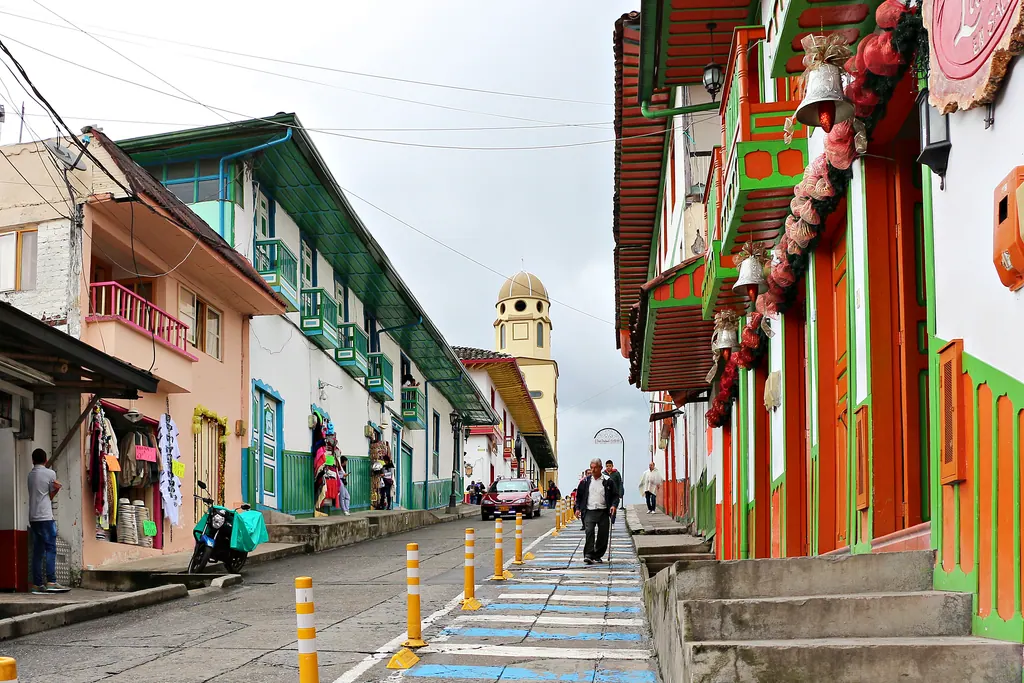
Salento is the region's best known town and the easiest base for the Cocora Valley. Its main street, Calle Real, is lined with low houses with balconies painted in bright reds, blues and greens, many of them now craft shops and cafés. At the end of the street, steps lead up to the Alto de la Cruz viewpoint, with views over the valley. Salento is busy on weekends and Colombian holidays, so book ahead if you plan to stay then.
Filandia, about half an hour away, has the same painted architecture with fewer visitors. Its wooden lookout tower gives a wide view over the coffee hills, and on a clear day you can see far into the surrounding valleys.
Further north, Manizales is a lively university city with steep streets and cable cars, and the gateway to the high-altitude páramo landscapes of Los Nevados.
Visiting a Coffee Farm
A farm tour is the reason many people come, and the region offers everything from small family fincas to larger estates with tasting rooms. A typical tour takes two to three hours: you walk among the coffee plants, learn how the cherries are picked by hand on the steep slopes, see how the beans are washed and dried, and finish with a tasting.
Timing helps. The main harvest in this part of Colombia usually runs from about September or October to December, with a smaller harvest, the mitaca, around April to June. During the harvest you are more likely to see pickers at work and beans drying in the sun.
If you are traveling with children or want something less traditional, the Parque del Café near Montenegro in Quindío is a theme park built around coffee, with rides, a coffee museum and gardens.
Hot Springs, Birds and Slow Days
The Coffee Region rewards slow travel. A few more ideas:
- Hot springs. The thermal pools at Santa Rosa de Cabal in Risaralda are set at the foot of a high waterfall and make a good half-day trip from Pereira.
- Birdwatching. Colombia has more bird species than any other country, and the cloud forests around the Coffee Region are rich in hummingbirds, tanagers and toucans.
- Farm stays. Many old coffee farms now take guests. Waking up to mist over the coffee plants is half the point.
When to Go
The region is green all year, with two drier periods, roughly December to February and June to August, and two wetter ones, roughly March to May and September to November. Rain usually comes as afternoon showers rather than days of downpour, but trails get slippery in the wet months. Mornings are often the clearest time of day in any season.
Is the Coffee Region Safe for American Travelers?
As of November 11, 2026, the U.S. State Department rates Colombia as a whole Level 3, "Reconsider Travel," in an advisory issued March 31, 2026, citing crime, terrorism, civil unrest, kidnapping and natural disasters. The advisory lists several departments as Level 4, "Do Not Travel": Arauca, Cauca (except Popayán), Valle del Cauca (except Cali) and Norte de Santander.
Quindío, Risaralda and Caldas are not on the Level 4 list, and they are the core of the Coffee Region that most visitors see. Note, however, that a small part of the UNESCO landscape lies in northern Valle del Cauca, which falls under the Level 4 warning. Use registered taxis or ride-hailing apps, avoid displaying valuables, and follow local advice on hiking routes. For how to read the levels, see our guide to travel advisory levels.
Getting There and Getting Around
The region's airports are small, so most travelers from the U.S. connect through Bogotá, Medellín or Panama City to Pereira or Armenia, both roughly an hour or less by road from Salento. Buses link the towns frequently, and the classic Willys jeeps still carry people and cargo to the villages and to the Cocora Valley.
How Many Days Do You Need?
Three or four nights is a good start: one base in Salento or Filandia for the Cocora Valley and a farm tour, with a day for hot springs or Manizales if you want more. Add a night or two at a farm stay and you will understand why Colombians speak of this region with such affection. Fly in through Bogotá or Medellín, and the Coffee Region fits neatly into a first trip to Colombia.
More ideas for the continent are on our South America page.
Frequently asked questions
Where is Colombia's Coffee Region?
In the Andes west of Bogotá, between Medellín and Cali, mainly in the departments of Quindío, Risaralda and Caldas, with the cities of Armenia, Pereira and Manizales.
How tall are the wax palms in the Cocora Valley?
The Quindío wax palm, Colombia's national tree, can grow to around 200 feet (60 meters), which makes it the tallest palm in the world.
How many days do you need in the Coffee Region?
Three or four nights is a good start, enough for the Cocora Valley, a coffee farm tour and one more day trip such as the hot springs at Santa Rosa de Cabal.
Is the Coffee Region safe to visit?
As of November 11, 2026, the State Department rates Colombia Level 3 overall. Quindío, Risaralda and Caldas are not among the Level 4 departments, but northern Valle del Cauca is.