Most people picture Mauritius as a postcard: a white beach, a turquoise lagoon and a resort pool. That version is real, and it is lovely. But fly over the southwest corner of the island and you see something else: a basalt mountain rising straight out of the reef, green gorges cutting into the high plateau, and a waterfall dropping into a jungle-lined crater.
Mauritius is a volcanic island in the Indian Ocean, about 1,200 miles (roughly 2,000 kilometers) off the coast of southeast Africa. It is small, around 40 miles (65 kilometers) from north to south, which means mountains, forests, rum distilleries and lagoons are rarely more than an hour or two apart by car. Here is how to see the side of Mauritius that most beach vacations skip.
Le Morne Brabant: A Mountain With a Story
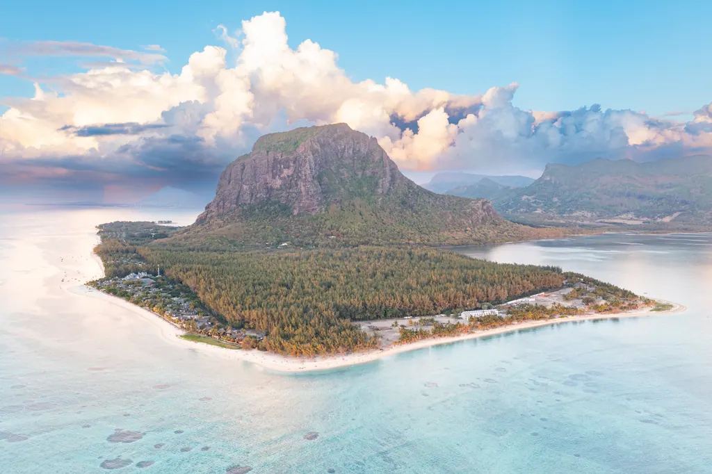
The southwest tip of the island is dominated by Le Morne Brabant, a 1,824 foot (556 meter) basalt monolith with lagoons on three sides. From the air, it looks almost unreal, and it is the image most often used to sell the island.
The mountain also has one of the most important stories in Mauritian history. In the 18th and early 19th centuries, enslaved people who escaped from plantations, known as maroons, used the steep cliffs and caves of Le Morne as a refuge. The mountain became a symbol of the fight against slavery, and in 2008 UNESCO listed the Le Morne Cultural Landscape as a World Heritage Site. A memorial at the foot of the mountain tells the story.
You can hike Le Morne. The lower part of the trail is a steady climb, and the upper section is steep, rocky and partly a scramble. Many visitors go with a local guide, and starting early is wise, before the heat builds. The reward at the top is a view over the lagoon and the reef that wraps around the peninsula.
The Underwater Waterfall Illusion
Off the coast of Le Morne lies one of the island's most photographed sights, and you cannot actually swim to it. Seen from above, sand and silt running off the edge of the shallow shelf into deeper water create patterns that look like a waterfall plunging into the ocean.
It is an optical illusion, and it is only really visible from the air. Helicopter and seaplane tours fly over it from several points on the island. Prices are high, but if you are going to splurge on one experience in Mauritius, this is a strong candidate. Check the weather before you book, as low clouds can hide the view.
Chamarel: Waterfalls and Colored Sand
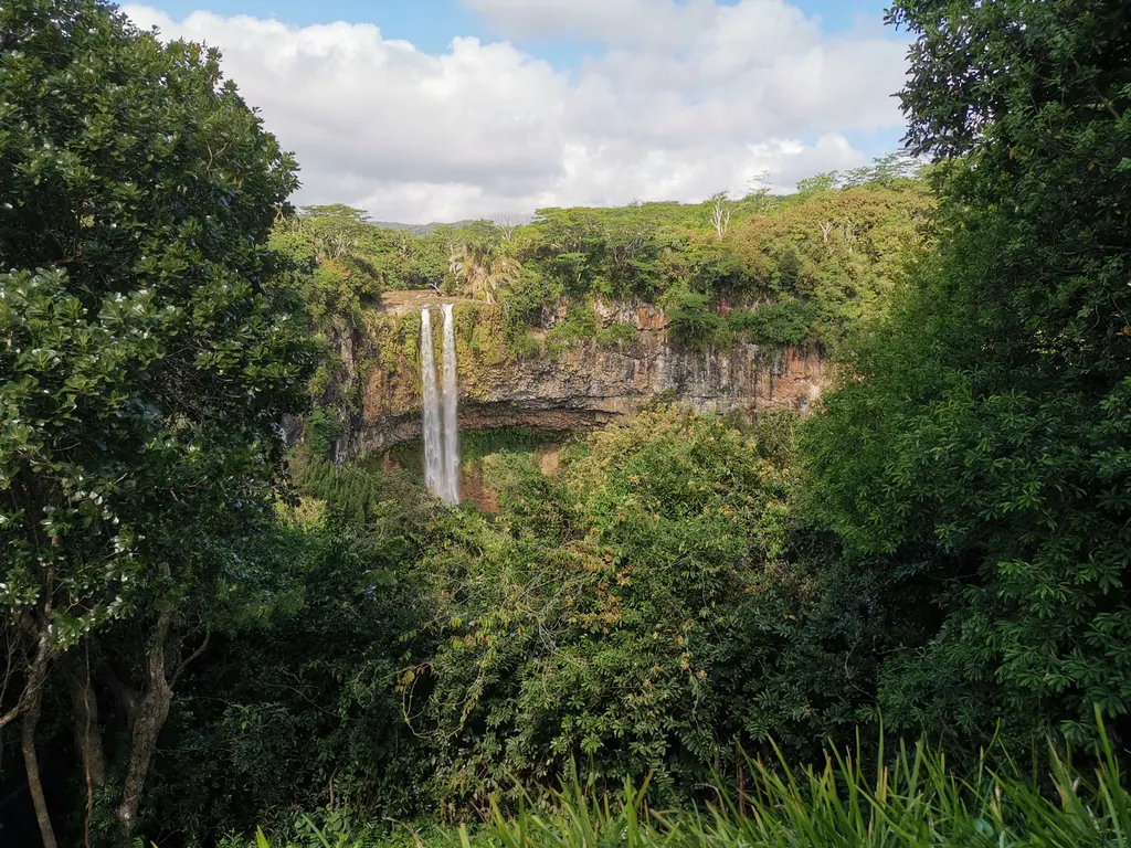
Inland from Le Morne, the road climbs into the hills around the village of Chamarel. Two of the island's best known natural sights are here, close together.
Chamarel Waterfall plunges in two streams over a cliff of layered basalt into a deep, forested gorge. It is one of the tallest on the island, with a drop often given as roughly 300 feet (around 90 to 100 meters), and you can see it from a viewing platform a short walk from the parking area.
A few minutes away are the Seven Coloured Earths, a small area of rolling dunes where volcanic soil has weathered into bands of red, brown, violet and yellow sand. It is more of a curiosity than a grand landscape, but it is an easy stop on the same visit. The area is part of a private park with an entrance fee that covers both sights.
The Chamarel area is also home to a rum distillery and a handful of restaurants with views toward the coast, which makes it a natural half-day trip from the west coast resorts.
Black River Gorges National Park
Mauritius' largest national park covers about 25 square miles (6,574 hectares) of the island's southwestern uplands. Black River Gorges National Park was established in 1994 to protect what is left of the island's native forest, and it is the best place to understand how unusual the wildlife of Mauritius is.
Marked trails run through the park, from short walks to viewpoints to longer hikes down into the gorges. The island's highest point, Piton de la Petite Rivière Noire, reaches 2,717 feet (828 meters) at the edge of the park. Bring water, good shoes and rain protection, as the weather in the uplands changes quickly.
Rare Birds and Island Conservation
Mauritius is famous for a bird that is no longer here: the dodo, which was hunted and outcompeted into extinction in the 17th century. Less well known is that the island has since become a conservation success story.
The Mauritius kestrel was once one of the rarest birds in the world, with only four known wild birds in 1974. The pink pigeon was down to around nine or ten wild birds by 1990. Thanks to decades of captive breeding and habitat restoration, both species now number in the hundreds. With some patience and luck, you may see them in Black River Gorges.
For a closer look, take a guided tour to Île aux Aigrettes, a small coral island off the southeast coast near Mahébourg. It is a nature reserve run by the Mauritian Wildlife Foundation, where native coastal forest has been restored and giant tortoises roam freely. Visits are by guided tour only, which keeps the reserve protected.
History and Food in Port Louis
The capital, Port Louis, is the best place to see how many cultures have shaped the island. Mauritius has no Indigenous population; it was settled by Dutch, French and British colonists, enslaved Africans and Malagasy, indentured laborers from India and traders from China. That mix shows up everywhere, from the languages on the street to the food.
On the waterfront, the Aapravasi Ghat, a UNESCO World Heritage Site since 2006, preserves the remains of the immigration depot where nearly half a million indentured laborers arrived from India and elsewhere in the 19th and early 20th centuries. Many Mauritians today descend from them.
Nearby, the Central Market is the place to try street food. Look for dholl puri, a soft flatbread filled with ground yellow split peas and served with curry and chutney, and gâteaux piments, small fried chili and split pea fritters. Mauritian Creole is the everyday language, though English and French are widely understood.
North of the capital, the Sir Seewoosagur Ramgoolam Botanical Garden at Pamplemousses dates back to the 18th century and is known for its ponds of giant water lilies.
When to Go and How to Get There
Mauritius is in the Southern Hemisphere, so the seasons are the reverse of North America's. The warm, humid summer runs from about November to April, when temperatures on the coast often reach the mid 80s°F (around 30°C). This is also the main season for tropical cyclones, so build some flexibility into your plans. The cooler, drier months from about May to October bring coastal temperatures in the 70s°F (around 21°C to 26°C) and are the most comfortable for hiking in the uplands.
There are no nonstop flights from the United States. Most American travelers connect through Dubai, Paris or Johannesburg. The local currency is the Mauritian rupee, and credit cards are widely accepted at hotels and larger restaurants. Check the latest entry rules for U.S. citizens with the U.S. State Department before you travel.
If you are building a bigger trip, Mauritius pairs well with South Africa, and you can find more inspiration in our coverage of Africa and nature travel. For another island escape off the African coast, see our guide to the best time to visit Cape Verde.
Planning a Few Days Away From the Beach
You do not have to choose between the lagoon and the mountains. A simple plan is to base yourself on the west or southwest coast, spend the mornings exploring and the afternoons by the water. Hike Le Morne on one morning, drive up to Chamarel on another, and save a third for the trails of Black River Gorges. Add a day in Port Louis and a half day on Île aux Aigrettes, and you will leave knowing Mauritius as much more than a beautiful beach.
Frequently asked questions
What is there to do in Mauritius besides the beach?
You can hike Le Morne Brabant, visit Chamarel Waterfall and the Seven Coloured Earths, walk the trails of Black River Gorges National Park, take a guided tour of Île aux Aigrettes and explore Port Louis.
Can you swim to the underwater waterfall in Mauritius?
No. The underwater waterfall off Le Morne is an optical illusion created by sand and silt flowing into deeper water, and it is best seen from a helicopter or seaplane.
When is the best time to visit Mauritius for hiking?
The cooler, drier months from about May to October are the most comfortable for hiking. November to April is hot and humid and is also the main cyclone season.
Are there direct flights from the U.S. to Mauritius?
No. Most American travelers connect through hubs such as Dubai, Paris or Johannesburg.